08 November 2019 (15:40 UTC-07 Tango 06) 17 Aban 1398/10 Rabi ‘al-Awwal 1441/12 Yi-Hai 4717
NASA’s aged and heavily modified DC-8 airliner is conducting air monitoring missions in relation to the growing wildfire danger in the western U.S.

Idaho National Guard A-10Cs in the foreground, NASA’s DC-8 FIREX-AQ takes off from Gowen Field (Boise Airport), 30JUL2019.
President Donald Trump is portrayed by the ‘main-stream’ news media as being anti-climate, yet since he became President of the United States NASA (National Aeronautics Space Administration) has seemingly increased its studies of the effects of pollution and wildfires (including prescribed burns and agricultural fires) on the atmosphere.

On 23JUL2019, NASA held an explainer day for Idaho news media, and as you can tell not many showed up. Idaho Air National Guard photo by Master Sergeant Joshua C. Allmaras.
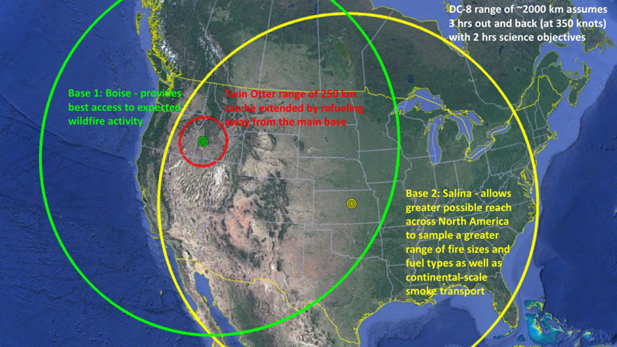
The latest study is called FIREX-AQ (Fire Influence on Regional to Global Environments and Air Quality), and from 22 July thru 18 August it called Gowen Field, Idaho, its home base.

Loading computers onto a Twin Otter.
FIREX-AQ also uses Twin Otter aircraft from NOAA (National Oceanic Atmospheric Administration), as well as satellites.

NASA’s ER-2 ‘climate-spy-plane’ based in California is also used.
From 19 August to 05 September FIREX-AQ was based on Salina Regional Airport, Kansas.

The final stage of the FIREX-AQ mission will be in Utah. (Update on the Fire and Smoke Model Evaluation Experiment)
On 08 August, while flying out-of Idaho NASA Made a Rare Flight Right Through a Thundercloud Formed by a Wildfire.

Looking like chaff/flare dispensers these are actually Airborne-Synthetic Aperture Radar (AirSAR) antenna. NASA photo 26MAR1998.
NASA says their DC-8 flys at 42-thousand feet (12-thousand-801 meters or 12.80 kilometers) for as long as 12 hours, collecting air samples with the many antennae protruding from the fuselage.

NASA DC-8 to Fly Low Over Los Angeles Basin and San Joaquin Valley
What It’s Like to Work in a Flying Smoke Laboratory
Video from 2018, NASA’s DC-8 super-particulate-sniffer in Germany:
NASA ER-2 ‘CLIMATE SPY PLANE’ PROVES CALIFORNIA’S STRICT ANTI-POLLUTION LAWS ARE A JOKE!
RED BANK & SOUTH FIRE HELICOPTER OPS
A-10C SNOWBLIND WALKAROUND IN IDAHO!

In 2016, the NASA DC-8 was in Korea conducting high-altitude monitoring of air quality, from Osan Air Base. U.S. Air Force photo by Technical Sergeant Travis Edwards, 27APR2016.
Video explainer of NASA’s DC-8 mission over Korea:


